Machu Picchu map: plan of the Inca city
Our own plan of Machu Picchu with 20 highlights, the terraces, the Guardhouse with the postcard view, the Temple of the Sun, Sacred Plaza, Intihuatana, Main Plaza and Temple of the Condor, the entrance with the bus terminal, the gate to Huayna Picchu and the path to the Inca Bridge. Plus the three official circuits in force since June 2024. Tap a number for details, choose your circuit, or print the map for your visit.
Map of the Inca city of Machu Picchu
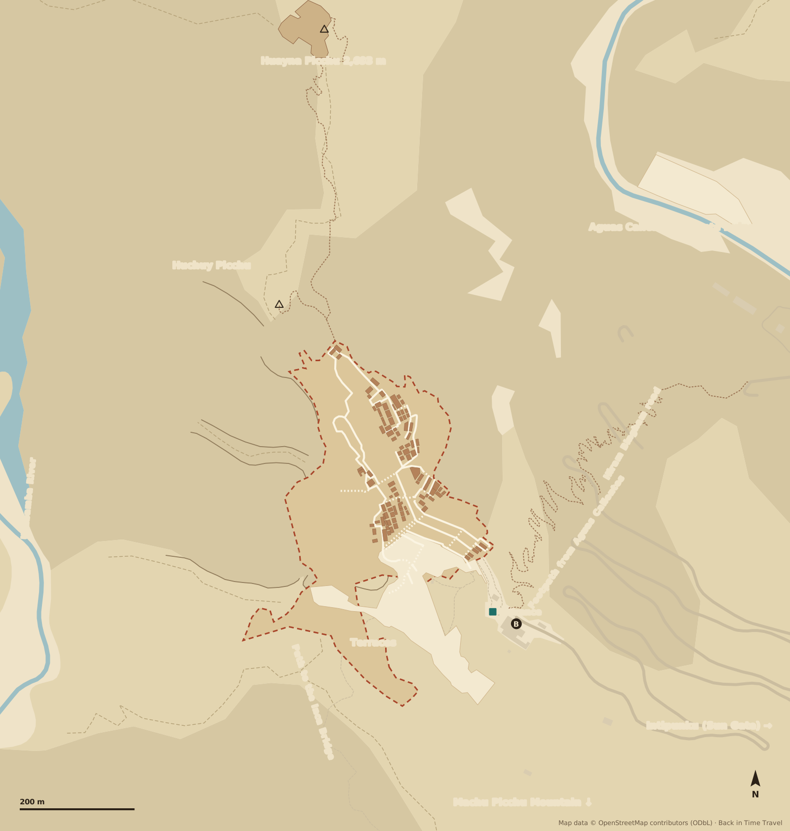
Map data © OpenStreetMap contributors, ODbL. Drawn by Back in Time Travel, data as of 25 September 2026. The map is a guide to orientation; paths, closures and the routing of the circuits may change, and the signs on site apply.
The 20 highlights on the map
The numbers match the map. The order follows the walk from the entrance across the terraces to the Guardhouse, through the city gate into the temple quarter and down to the Main Plaza, to the Sacred Rock at the foot of Huayna Picchu and through the eastern residential quarters to the Temple of the Condor; the Inca Bridge and Huayna Picchu are extra trails with their own route.
Entrance and control Machu Picchu Control
The only entrance, at the south-eastern edge of the city above the bus terminal: ticket and passport are checked, then the one-way walk of your circuit begins. Toilets, lockers and the restaurant are before the control; inside there is nothing more and no re-entry.
Read more →Guardhouse Casa del Guardián, postcard view
The thatched house on the topmost terrace above the city: this is where the picture everyone knows was taken, with the terraces, the Main Plaza and Huayna Picchu behind. Only Circuits 1 and 2 come up here; with Circuit 3 you see the city from below.
Agricultural terraces Andenes
The staircases of fields on the southern slope: hundreds of terraces with stone walls up to four metres high and drainage of gravel and sand. They held the slope and fed the city with maize and potatoes. Every circuit crosses them on the way up from the entrance or down again.
City gate Puerta de la Ciudad
The trapezoidal gate at the end of the path from the Guardhouse, the only access to the urban sector. From the gate it frames Huayna Picchu; inside you can still see the stone rings that held a bar across the door.
Quarry Cantera
A field of granite blocks above the temple quarter: this is where the Incas cut the stone for the city. A half-split block shows the technique of driving wedges into grooves and letting water crack the rock. The city was still unfinished when it was abandoned.
Temple of the Sun Templo del Sol, Torreón
The only round building in the city, set on a rock with smoothed blocks. At the June solstice the first light falls through the east window onto the altar stone. Only Circuit 3 reaches the wall; from Circuit 2 you look down onto it from above.
Read more →Royal Tomb Tumba Real
The cave beneath the Temple of the Sun, with steps and niches cut into the rock and masonry finer than anywhere else in the city. Hiram Bingham took it for a tomb; human bones were never found. Probably a shrine for the ancestors.
Fountains Fuentes, 16 fountains
Sixteen basins one above the other along the stairway between the Temple of the Sun and the Royal Palace: a spring on the northern slope feeds a 750-metre channel that lets the water fall basin by basin through the city. The top fountain served the palace, the lowest the residential quarters.
Royal Palace Residencia Real, Casa del Inka
The largest residence in the city, right beside the first fountain: a courtyard with rooms of the finest masonry, its own latrine and a garden. Probably the house of the ruler Pachacuti when he visited the city. On the route of Circuit 3.
Sacred Plaza and Principal Temple Plaza Sagrada, Templo Principal
The square of the great temples above the Main Plaza. The Principal Temple on the north side, three-walled with seven niches, stands on a foundation that has been settling for centuries and is pulling the wall apart. Next to it the Sacristy with the stones said to have 32 angles.
Temple of the Three Windows Templo de las Tres Ventanas
Three trapezoidal windows made of huge blocks, facing the sunrise over the mountains to the east. The chronicler Pachacuti Yamqui told of the three windows from which the ancestors of the Incas emerged; Bingham believed he had found Tampu Tocco here.
Intihuatana The hitching post of the sun
The stone carved from the bedrock on the highest point of the city, at the top of a stairway above the Sacred Plaza. Its edges point to the surrounding mountains; at the equinoxes it casts almost no shadow at midday. The last Intihuatana the Spaniards did not destroy. Only on Circuit 2 (route 2-A).
Read more →Main Plaza Plaza Principal
The lawn in the middle of the city that separates the temple quarter in the west from the residential quarters in the east; the llamas graze here. At its northern end lay the ceremonial square with the Sacred Rock. Our history of Machu Picchu begins here.
Read more →Sacred Rock Roca Sagrada
A three-metre monolith on a plinth whose outline traces the silhouette of Mount Yanantin behind it, framed by two open huts. The northernmost point of the city and the meeting point before the climb of Huayna Picchu.
Gate to Huayna Picchu Control hut, route 3-A
The trail up Huayna Picchu begins at the Sacred Rock: control hut, sign the book, then Inca stairs with steel cables, 260 metres of ascent, an hour up and an hour down. Only with a route 3-A ticket and in the booked time slot; children under twelve are not allowed.
Read more →Group of the Three Doorways Grupo de las Tres Portadas
Three identical residential compounds side by side on the northern edge of the residential quarters, each with a doorway towards the Main Plaza: the homes of the craftsmen and farmers who kept the city running. Part of the walk on Circuit 2.
Water Mirrors Espejos de Agua, Grupo de los Morteros
Two round, shallow basins in the floor of a house, which Bingham took for mortars. Filled with water they reflect the sky; the interpretation as instruments for watching the stars is popular but unproven.
Temple of the Condor Templo del Cóndor
Two rocks rise like raised wings, and on the ground in front lies a stone with the head and ruff of the bird: the condor, messenger between sky and earth. Beneath the wings a cave with niches, behind the temple the chambers Bingham called the prison.
Path to the Inca Bridge Camino a Puente Inka, route 1-D
Behind the Guardhouse the path branches off to the south-west and follows a narrow ledge in the cliff for 20 minutes to the viewing platform before the Inca Bridge: there a stretch of stone wall spans a six-metre gap with tree trunks; pull the trunks away and the access to the city was closed. The bridge lies 500 metres to the south, beyond the edge of the map, and may not be walked on.
Huayna Picchu Wayna Picchu, 2,693 metres
The steep mountain behind the city, 260 metres above the Main Plaza. On the summit are terraces and temples, on its back the Great Cave with the Temple of the Moon. Seen from above, the city forms the outline of a condor, or so the legend says. Only on route 3-A, 400 places a day.
Read more →
The three circuits through Machu Picchu
Since 1 June 2024 the rules of the Ministry of Culture apply (Resolución Ministerial 528-2023-MC): three circuits with ten routes, all one-way, all from the entrance. Your ticket is valid for exactly one route; which stops it covers is shown here. Choose a circuit and its stops are highlighted on the map.
Circuit 1 Panorámico: the postcard view from above
Routes 1-A to 1-D only climb the upper terraces to the Guardhouse with the classic view over the whole city; they do not enter the city itself. Depending on the route you add the climb of Machu Picchu Mountain (1-A, three hours, 3,082 metres), just the upper terrace (1-B), the Sun Gate Intipunku (1-C) or the Inca Bridge (1-D); 1-C and 1-D in high season only. The circuit for the photo, not for the temples.
Circuit 2 Machupicchu Clásico: the whole city
Route 2-A is the most complete walk: from the upper (2-A) or lower terrace (2-B) with the postcard view through the city gate to the quarry, across the Sacred Plaza with the Principal Temple and the Temple of the Three Windows up to the Intihuatana, down across the Main Plaza to the Sacred Rock and through the east with the Three Doorways, the Water Mirrors and the Temple of the Condor to the exit. Two and a half to three hours; you see the Temple of the Sun and the Royal Palace only from above.
Circuit 3 Machupicchu Realeza: the royal quarter below
Routes 3-A to 3-D stay in the lower part, without the Guardhouse: across the lower terraces to the Temple of the Sun with the Royal Tomb, along the fountains to the Royal Palace, then the Water Mirrors and the Temple of the Condor. Route 3-A adds the climb of Huayna Picchu (gate by the Sacred Rock, two hours there and back), 3-D the small Huchuy Picchu, 3-C the Great Cave (Temple of the Moon) on the back of Huayna Picchu; 3-C and 3-D in high season only.
Entrance, bus terminal and footpath
- Entrance with control
- The only entrance is at the south-eastern edge of the city, just above the bus terminal: ticket and passport check, toilets (fee), lockers, the Sanctuary Lodge restaurant and a snack bar. Large backpacks over 40 by 35 by 20 centimetres must stay outside. Entry at your booked hour, normally up to one hour after the slot begins.
- Bus terminal
- The buses from Aguas Calientes (Consettur) run from 5.30 am every few minutes up the Hiram Bingham road, about 25 minutes over 13 hairpin bends, terminating right in front of the entrance. Tickets are sold in Aguas Calientes on Avenida Hermanos Ayar, not up on the mountain.
- Footpath from Aguas Calientes
- If you walk, you cross the Urubamba at the Puente Ruinas (control open 5 am to 2 pm, show ticket and passport) and climb the Inca stairway that cuts across the hairpins: 400 metres of ascent, one and a half to two hours. By the bridge is the Museo de Sitio Manuel Chávez Ballón with the finds from the excavations.
- Toilets and food
- Only outside the control at the entrance; inside the city there are no toilets, no water and no re-entry. Once you leave after your circuit, you cannot go back in.
Prices, entry times, which route to book when, and how to get there by train and bus are in our guide to Machu Picchu tickets and admission.
Where is Machu Picchu?
Machu Picchu lies in the Cusco region of southern Peru, on a ridge 2,430 metres high above the valley of the Urubamba River, on the border between the Andes and the Amazon rainforest. At the foot of the mountain is Aguas Calientes (Machupicchu Pueblo), reachable only by train or on foot; trains run from Ollantaytambo in the Sacred Valley, about an hour and a half, and from Poroy near Cusco. Distances from the Main Plaza, as the crow flies:
- Aguas Calientes
- 2 km
- Ollantaytambo
- 32 km
- Urubamba
- 49 km
- Cusco
- 75 km
- Lima
- 504 km
Frequently asked questions about the Machu Picchu map
Where is Machu Picchu?
Machu Picchu lies in the Cusco region of southern Peru, 2,430 metres up on a ridge above the Urubamba River. As the crow flies it is 2 kilometres to Aguas Calientes at the foot of the mountain, 32 kilometres to Ollantaytambo, 75 kilometres to Cusco and 504 kilometres to Lima. The train from Ollantaytambo takes about an hour and a half to Aguas Calientes, the bus from there 25 minutes to the entrance.
How big is Machu Picchu?
The urban sector on the ridge measures about 500 by 200 metres; with the terraces and paths it covers a good 30 hectares, and the Santuario Histórico protected area more than 32,000. From the entrance to the Guardhouse you climb 100 metres; Circuit 2 is about three kilometres long and takes two and a half to three hours with photo stops.
Which circuit should I book?
Circuit 2 (route 2-A) if you are coming only once: postcard view and city, with the Intihuatana. Circuit 1 for the view plus a mountain, Circuit 3 for the royal quarter with the Temple of the Sun and for Huayna Picchu. The circuits are one-way and a ticket is valid for one route; to see two you need two tickets, ideally early morning and midday.
Is there a Machu Picchu map as a PDF?
This page can be printed or saved as a PDF with the “Print the map” button; the map, highlights and circuits are printed. There is no folding plan at the entrance, but boards show the routes; along the way signs and wardens point the way.
Where is the postcard view of Machu Picchu?
At the Guardhouse, number 2 on the map, on the topmost terrace above the entrance. Only Circuits 1 and 2 go up there; with Circuit 3 you get the view from the lower terraces. Early in the morning mist often lies over the city and lifts around 9 am.
How do I get from Aguas Calientes to Machu Picchu?
By bus from 5.30 am, 25 minutes up the Hiram Bingham road to the entrance, tickets on Avenida Hermanos Ayar. Or on foot: across the Puente Ruinas and up the Inca stairway, 400 metres of ascent, one and a half to two hours, control at the bridge from 5 am to 2 pm.
Can you climb Huayna Picchu and Machu Picchu Mountain?
Yes, each with its own route: Huayna Picchu belongs to Circuit 3 (route 3-A, gate by the Sacred Rock, an hour up), Machu Picchu Mountain to Circuit 1 (route 1-A, turn-off above the Guardhouse, three hours there and back). Both are limited to 400 and a few hundred places a day respectively and sell out weeks ahead.