Teotihuacan Map: Plan of the Pyramid City
Our own plan of Teotihuacan with 18 highlights, the Pyramids of the Sun and the Moon, the Avenue of the Dead, the residential compounds with murals and all five gates. Tap a number for details, choose a route or print the map for your visit.
Map of the Teotihuacan archaeological zone
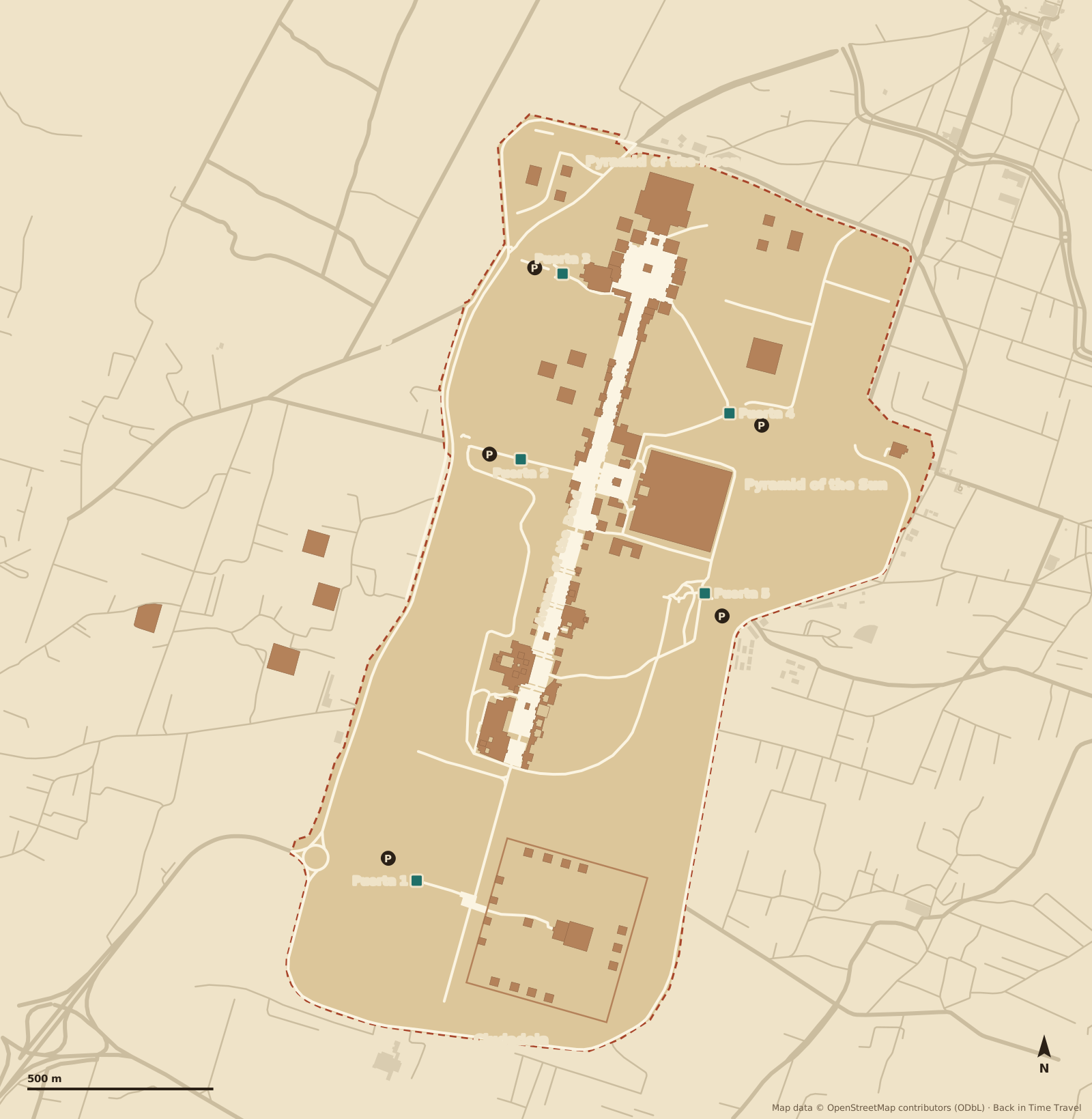
Map data © OpenStreetMap contributors, ODbL. Drawn by Back in Time Travel, data as of 25 September 2026. The map is a guide; paths, open areas and gates can change.
The 18 highlights on the map
The numbers match the map. The order follows the walk from Gate 1 at the Ciudadela along the Avenue of the Dead north to the Pyramid of the Moon, then the residential compounds with murals outside the fence.
Gate 1 (Puerta 1) Entrance
The main entrance in the south-west at the Ciudadela. Buses from Mexico City stop here; ticket office, toilets and souvenir stalls are right at the gate.
Read more →Ciudadela Enclosure
A square of 400 by 400 metres enclosed by platforms, probably the political and religious centre of the city. From the platform at the entrance you overlook the whole complex.
Temple of Quetzalcoatl Temple
The stepped pyramid of about AD 200 with stone heads of the Feathered Serpent and a rain or fire creature on its west facade. The platform built in front (Plataforma Adosada) later hid it; more than 200 sacrificial victims were found beneath the building.
Read more →Avenue of the Dead Processional avenue
The 40-metre-wide axis of the city, turned slightly to the north-east, laid out around AD 150 to 225. Its name comes from the Aztecs, who took the platforms for tombs. From the Río San Juan to the Pyramid of the Moon is a good 1.5 kilometres.
Read more →Edificios Superpuestos Building layers
The “superimposed buildings”: older floor levels are exposed beneath younger ones. The best place to see how the city built on top of itself.
Read more →Viking Group Residential buildings
A complex on the Avenue of the Dead, named after the Viking Fund that financed the excavation in 1942. Beneath the floor lay two thick layers of mica, whose purpose is still a puzzle.
Museum of Teotihuacan Culture Museum
The site museum of 1994 south of the Pyramid of the Sun, included in the ticket: finds, grave goods and a walk-over model of the city under glass, with the pyramid framed in the window. The botanical garden is next door.
Read more →Pyramid of the Sun Pyramid
About 225 metres a side and 65 metres high, built around AD 200 over a cave. The third-largest pyramid in the world; the staircase has been closed since 2021. Our history explains how the city was planned around it.
Read more →Puma Mural Mural
A puma with a feathered border under a shelter on the west side of the Avenue of the Dead, one of the few paintings still to be seen in place.
Temple of Agriculture Temple
Named after a mural of offerings discovered in 1884. The original is lost; remains and copies can be seen on site and in the Museum of Murals.
Palace of Quetzalpapalotl Palace
The courtyard rebuilt in 1962, with pillars carved with the quetzal-butterfly and inset obsidian eyes. Beneath it lie the older Palace of the Jaguars with jaguar paintings and the Temple of the Feathered Conches.
Plaza of the Moon Square
The square in front of the Pyramid of the Moon with an altar in the centre and twelve platforms around it. From the south edge you have the best view of the pyramid and of Cerro Gordo behind it, whose shape it repeats.
Pyramid of the Moon Pyramid
About 43 metres high, built in seven phases over two centuries, with sacrificial burials of people, jaguars and eagles in its core. The Avenue of the Dead ends here; the staircase is closed, as at the Pyramid of the Sun.
Museum of Teotihuacan Murals Museum
The “Beatriz de la Fuente” museum at Gate 3, open since 2001 and included in the ticket: detached murals from Techinantitla and other compounds, well explained. The quietest place in the zone.
Read more →Tepantitla Residential compound
The compound east of the Pyramid of the Sun, outside the fence by Gate 4, with the famous Tlalocan mural: people bathing and playing beneath a goddess, an image of paradise.
Tetitla Residential compound
A compound with more than a hundred paintings in several courtyards, west of the zone on the ring road: jaguars, eagles, the Great Goddess. Usually almost empty, included in the ticket.
Yayahuala Residential compound
A large compound from the 1960s excavations, right next to Tetitla. It is often only visible from outside; its walls show how densely the city was built beyond the centre.
Atetelco Residential compound
The westernmost compound, 15 minutes on foot from Tetitla. In the “white courtyard” murals with processions of coyotes and jaguars have been reconstructed; a second courtyard shows warriors in a net pattern.
Routes through Teotihuacan
Three suggestions. Choose a route and its stops are highlighted on the map. The zone opens at 9 am; there is almost no shade, so water and a hat are essential.
The highlights in 3 hours
From Gate 1 through the Ciudadela to the Temple of Quetzalcoatl, then up the Avenue of the Dead to the Pyramid of the Sun, the Palace of Quetzalpapalotl and the Pyramid of the Moon. Leave by Gate 3 and take a taxi back.
The whole day with murals and museums
Everything from the short route, plus the mica floors of the Viking Group, the Museum of Teotihuacan Culture, the Museum of Murals and the compounds Tepantitla, Tetitla, Yayahuala and Atetelco outside the fence. Seven to eight hours with breaks.
- 1 Gate 1 (Puerta 1)
- 2 Ciudadela
- 3 Temple of Quetzalcoatl
- 4 Avenue of the Dead
- 5 Edificios Superpuestos
- 6 Viking Group
- 7 Museum of Teotihuacan Culture
- 8 Pyramid of the Sun
- 9 Puma Mural
- 10 Temple of Agriculture
- 11 Palace of Quetzalpapalotl
- 12 Plaza of the Moon
- 13 Pyramid of the Moon
- 14 Museum of Teotihuacan Murals
- 15 Tepantitla
- 16 Tetitla
- 17 Yayahuala
- 18 Atetelco
Short and out of the sun: 9 am start
Start at Gate 2 when the zone opens: Pyramid of the Sun, Puma Mural, Palace of Quetzalpapalotl, Plaza of the Moon and Pyramid of the Moon, then the Museum of Murals at Gate 3. Two hours, before the heat and the coach groups arrive.
The five gates
- Gate 1, Puerta 1 (Ciudadela)
- In the south-west at the Ciudadela, right by the motorway exit. Buses from Mexico City stop here. Start here and you walk the whole Avenue of the Dead northwards.
- Gate 2, Puerta 2 (Pyramid of the Sun)
- In the west opposite the Pyramid of the Sun, with the largest car park, restaurants and stalls. The shortest way to both great pyramids.
- Gate 3, Puerta 3 (Pyramid of the Moon)
- In the north behind the Pyramid of the Moon, next to the Museum of Teotihuacan Murals. Handy if you finish in the north and take a taxi back.
- Gate 4, Puerta 4 (Tepantitla)
- In the east, east of the Pyramid of the Sun. From here it is a few minutes on foot to the Tepantitla compound with the Tlalocan mural.
- Gate 5, Puerta 5 (museum)
- In the south-east by the Museum of Teotihuacan Culture and the botanical garden, near the La Gruta restaurant.
- Parking
- All five gates have paid car parks (Gate 2 is the largest). Taxis wait at Gates 1, 2 and 3 and shuttle between the gates for a few pesos, so you do not have to walk back.
Prices, opening hours and how to get there by bus from Mexico City are in our guide Teotihuacan tickets and admission.
Where is Teotihuacan?
Teotihuacan lies in the State of Mexico, about 40 kilometres north-east of the centre of Mexico City, in a high valley at 2,300 metres. By road it is about 50 kilometres on the México–Pirámides motorway (132D), roughly an hour without traffic. Distances from the Pyramid of the Sun, as the crow flies:
- Mexico City (Zócalo)
- 42 km
- Mexico City Airport (AICM)
- 37 km
- Pachuca
- 46 km
- Puebla
- 99 km
- Querétaro
- 190 km
Frequently asked questions about the Teotihuacan map
Where is Teotihuacan?
Teotihuacan lies in the State of Mexico, about 42 kilometres north-east of the Zócalo in Mexico City as the crow flies and 37 kilometres from the AICM airport; by road it is about 50 kilometres on the México–Pirámides motorway. Pachuca is 46 kilometres to the north, Puebla 99 kilometres to the south-east. The zone belongs to the municipality of Teotihuacán de Arista; the town of San Juan Teotihuacán lies directly to the west, San Martín de las Pirámides to the north-east.
How big is Teotihuacan?
The fenced zone runs from the Ciudadela in the south to the Pyramid of the Moon in the north, a good two kilometres along the Avenue of the Dead. The ancient city was far larger, about 20 square kilometres; the compounds Tetitla, Atetelco and Tepantitla lie outside the fence. The highlights take three hours, with murals and museums a full day.
Which Teotihuacan gate is the best?
By bus: Gate 1 at the Ciudadela, where the buses from Mexico City stop. By car: Gate 2 opposite the Pyramid of the Sun, the largest car park and the shortest walk to both pyramids. If you finish in the north at the Pyramid of the Moon, leave by Gate 3 and take a taxi back.
Can you climb the pyramids?
No. The staircases of the Pyramids of the Sun and the Moon have been closed since 2021, and INAH had not reopened them by the date we checked. The best views of both pyramids are from the Plaza of the Moon and from the platform at the entrance to the Ciudadela.
Is there a printable Teotihuacan map?
Yes: use the “Print map or save as PDF” button on this page. It prints the map, the highlights and the routes. There are also information boards at the gates, and the stalls at Gates 1 and 2 sell printed plans.
How do I get from Mexico City to Teotihuacan?
By Autobuses Teotihuacán bus from the Terminal Central del Norte (Metro Autobuses del Norte), about an hour; it stops at Gate 1 and on request at Gate 2. By car on the México–Pirámides motorway (132D), about 50 kilometres. A taxi or Uber costs many times the bus fare; tours pick you up at your hotel.
Where can I see the murals?
In place at the Puma Mural and in the Palace of Quetzalpapalotl on the Avenue of the Dead, and in the compounds outside the fence: Tepantitla with the Tlalocan painting by Gate 4, Tetitla and Atetelco in the west. Detached murals hang in the Museum of Murals at Gate 3. All are included in the ticket.