Tikal Map: Plan of the Maya Ruins
Our own plan of Tikal with 19 highlights, the Great Plaza, Temples I to VI, Mundo Perdido, the four causeways and the walk from the car park into the ruins. Tap a number for details, choose a route or print the map for your visit.
Map of the Maya city of Tikal
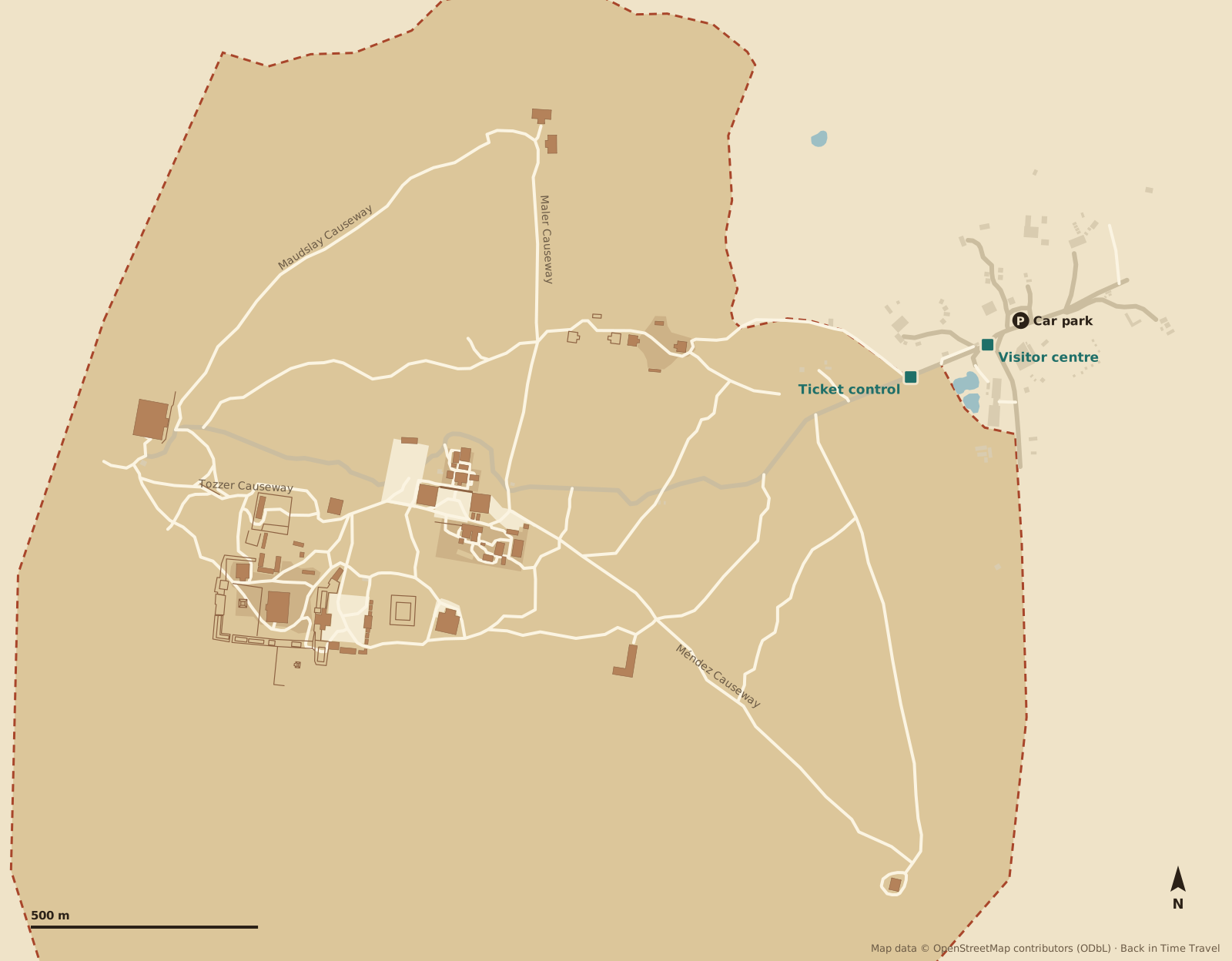
Map data © OpenStreetMap contributors, ODbL. Drawn by Back in Time Travel, data as of 25 September 2026. The map is a guide; trails, closures and which temples may be climbed can change.
The 19 highlights on the map
The numbers match the map. The order follows a circuit from the ticket control in the east past the twin-pyramid complexes to the Great Plaza, west to Temple IV, back via Mundo Perdido and Temple V, and finally along the Méndez Causeway to the Temple of Inscriptions.
Ticket control Entrance
The start of the trail into the ruins, about 300 metres from the car park. Your pre-purchased ticket is checked here. From here it is a good kilometre to the Great Plaza.
Read more →Complex Q Twin-pyramid complex
The best restored of the twin-pyramid complexes, built in 771 AD to mark the end of a k’atun (20-year cycle). In the northern enclosure stand Stela 22 and Altar 10 with the image of the ruler Yax Nuun Ahiin II.
Complex R Twin-pyramid complex
Tikal’s last twin-pyramid complex, 790 AD, barely restored: the pyramids are overgrown mounds, Stela 19 and Altar 6 still stand in place. The Maler Causeway branches off north from here.
Group H and Complex P Northern group
At the end of the Maler Causeway, 700 metres north: a large platform with unrestored temples and the twin-pyramid Complex P of 751 AD with Stela 20 and Altar 8. Quiet, often with no other visitors at all.
Great Plaza Heart of the city
The central square between Temples I and II, lined with the stelae and altars of the kings. The North and Central Acropolis frame it to the north and south. Our history of Tikal begins here.
Read more →Temple I Temple of the Great Jaguar
Tikal’s landmark, 47 metres high, built around 734 AD as the funerary temple of Jasaw Chan K’awiil I. His tomb (Burial 116) with its jade lay in the core of the pyramid. Climbing is prohibited.
Read more →Temple II Temple of the Masks
Facing Temple I, 38 metres high, around 700 AD, probably dedicated to the king’s wife. A wooden staircase takes you to the platform with the classic view over the plaza.
North Acropolis Royal necropolis
For more than a thousand years, from about 350 BC, the burial place of the rulers: temple upon temple, stucco masks, rows of stelae in front. The most important place for the early history of the city.
Central Acropolis Palace quarter
A maze of 45 palace buildings around six courtyards south of the plaza: home and seat of government of the royal family. Maler’s Palace with its graffiti is the best-known building.
Temple III Temple of the Jaguar Priest
Tikal’s last great temple, around 810 AD, 55 metres high and unrestored: a wooded mound with the temple building exposed. The carved lintel shows a corpulent figure in a jaguar skin.
Bat Palace Palacio de las Ventanas
A two-storey palace west of Temple III with real windows, a rarity in Maya architecture. On the way to the Tozzer Causeway, which continues west to Temple IV.
Complex N Stela 16 and Altar 5
Twin-pyramid complex of 711 AD at the foot of Temple IV. In the enclosure stand Stela 16 with the portrait of Jasaw Chan K’awiil I and Altar 5, on which the king and an allied lord rebury the bones of a woman.
Temple IV Temple of the Two-Headed Serpent
At around 65 metres the tallest structure at Tikal, around 741 AD under Yik’in Chan K’awiil. Wooden stairs lead to the platform: from here the roof combs of Temples I, II, III and V rise out of the forest. The place for sunrise.
Read more →Mundo Perdido Lost World
The oldest part of the city: the 31-metre Great Pyramid with stairways on all four sides and the row of temples in front of it form an astronomical complex whose origins go back to the 7th century BC.
Plaza of the Seven Temples Plaza de los Siete Templos
Seven small temples in a row on the east side of a wide plaza, with a triple ball court to the north, unique in the Maya world. The plaza was only cleared in the 2000s.
Temple V Second-tallest temple
57 metres high, around 700 AD and thus older than Temple I; restored in the 1990s. The steep stairway may no longer be climbed. A path leads across from the Central Acropolis to the south.
Group G Palacio de las Acanaladuras
A large palace complex on the Méndez Causeway with several courtyards. You enter the inner court through a tunnel whose entrance is shaped as the mouth of a monster. The facades carry the grooves that give the palace its name.
Temple VI Temple of Inscriptions
At the end of the Méndez Causeway, 1.3 kilometres south-east of the plaza: a small temple with a 12-metre roof comb carrying the longest hieroglyphic text at Tikal. Dedicated in 766 AD, it reaches back to mythical dates in 1139 BC.
Museums and visitor centre Museo Morley and Museo Lítico
By the car park: the Museo Sylvanus G. Morley shows ceramics, jade and the reconstructed Burial 116 of Jasaw Chan K’awiil I; the Museo Lítico shows stelae, altars and a model of the city. Separate ticket; comedores and toilets next door.
Read more →
Routes through Tikal
Three suggestions, all from the ticket control. Choose a route and its stops are highlighted on the map. Allow for slow walking in the forest: the groups are often several hundred metres apart.
The highlights in 3 hours
From the entrance via Complex Q to the Great Plaza with Temples I and II and both acropolises, then west up Temple IV and back via Mundo Perdido.
The whole day
All 19 stops, including the detour along the Maler Causeway to Group H and the walk along the Méndez Causeway to the Temple of Inscriptions. About twelve kilometres, six to eight hours with breaks.
Sunrise from Temple IV
With a sunrise ticket and guide, straight to Temple IV at 4.30 am, then via Complex N, the Bat Palace and Temple III to the still empty Great Plaza, finishing with Mundo Perdido, the Plaza of the Seven Temples and Temple V.
Entrance, car park and visitor centre
- Ticket control
- At the start of the trail into the ruins, about 300 metres west of the car park. Your ticket is checked here (buy in advance at Banrural or online, not at the control). From here it is a good kilometre through the forest to the Great Plaza.
- Visitor centre
- At the end of the access road: car park, the two museums, several comedores, a small model of the city and the three hotels inside the park (Jaguar Inn, Tikal Inn, Jungle Lodge). Toilets are here and at only a few points in the ruins.
- Car park
- Free, on bare ground by the visitor centre; the national park gate with the first ticket check is 17 kilometres earlier on the road from Flores. Shuttles and coaches stop at the same place.
Prices, opening hours, the sunrise ticket and the museums are in our guide Tikal tickets and admission.
Where is Tikal?
Tikal lies in northern Guatemala, in the department of Petén, deep in the rainforest of the Maya Biosphere Reserve. The nearest town is Flores with Mundo Maya airport, 64 kilometres and a good hour away by road. The Belize border is about 100 kilometres by road. Distances from the Great Plaza, as the crow flies:
- Flores
- 44 km
- Guatemala City
- 303 km
- Belize City
- 155 km
- San Ignacio (Belize)
- 59 km
- Cancún
- 526 km
Frequently asked questions about the Tikal map
Where is Tikal?
Tikal lies in the department of Petén in northern Guatemala, 44 kilometres north-east of Flores as the crow flies (64 kilometres by road, a good hour), 155 kilometres west of Belize City and 303 kilometres north of Guatemala City, more than 500 kilometres by road. The nearest airport is Mundo Maya near Flores.
How big is Tikal?
The core zone you explore on foot measures about two and a half by two kilometres; the whole city with its residential districts covered more than 60 square kilometres. From the car park to the Great Plaza is a good kilometre and a half, to Temple IV another 700 metres. The highlights take three hours, all 19 stops a whole day.
Is there a printable Tikal map?
Yes: use the “Print map or save as PDF” button on this page. It prints the map, the highlights and the routes. There is also a model of the city at the visitor centre, and signs at the junctions in the forest point to the groups.
Which temples can you climb at Tikal?
Temple IV by wooden stairs to the platform with the famous view, and Temple II to the platform overlooking the plaza. Temples I, III and V are closed, as are some buildings of the North Acropolis. Access changes; the signs on site apply.
Is sunrise from Temple IV worth it?
Yes, if you are happy to get up early: with the sunrise ticket you enter at about 4.30 am with a guide and sit on Temple IV at dawn while howler monkeys and toucans wake. Mist often lies over the forest, so the experience is less the sun itself than the jungle waking up. Details on our tickets page.
How far is it from Flores to Tikal?
64 kilometres by road, a good hour by shuttle, taxi or hire car via El Remate. Shuttles run from about 4.30 am; day trips from Flores, El Remate and from San Ignacio in Belize are the most common way to visit.
What are the causeways at Tikal?
The four paved causeways (calzadas) linked the districts of the city: the Tozzer Causeway leads west from the plaza to Temple IV, the Maler Causeway north to Group H, the Maudslay Causeway connects Temple IV with Group H, and the Méndez Causeway runs south-east to the Temple of Inscriptions. Today they are the main trails through the forest.