← Back to the time atlas

Guatemala · Maya

Tikal.
Above the trees.

The temples draw your eyes upwards. To understand this Maya city, look also at its plazas, political relationships and water reservoirs.

c. 600 BCE–950 CE

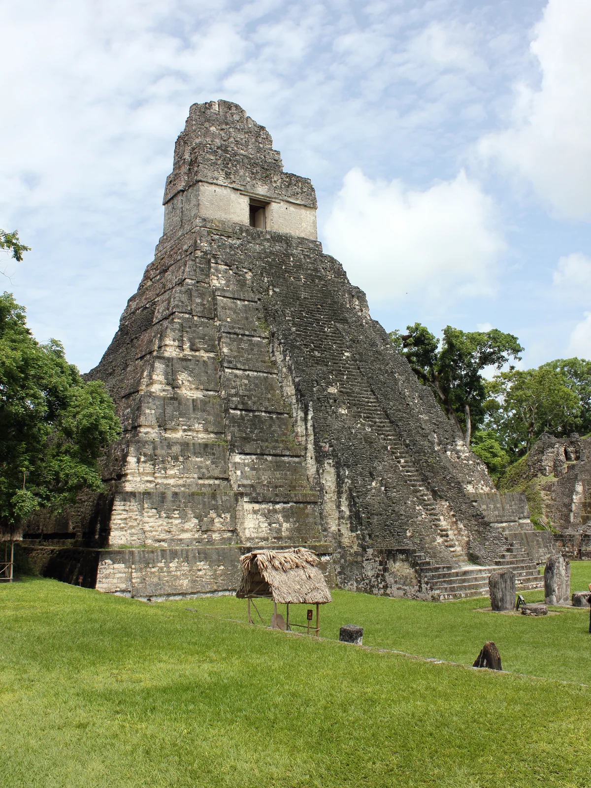
The steep stone staircase and tall roof comb of Temple I at Tikal, surrounded by greenery.
Temple I at the Great Plaza of Tikal, Guatemala. Photograph taken on 26 June 2015. Kaldari · CC0 1.0
More than a collection of temples.

Tikal lies in modern-day Petén, Guatemala. Its archaeological remains include residential areas and reservoirs as well as monuments. The national park protects both cultural and natural heritage. Source: UNESCO · Tikal National Park

Through the centuries

No place stands still.

Choose a period. See how the story changes over time.

From c. 600 BCE

Before the famous temples.

Tikal’s history reaches back into the Preclassic period. Moving far back on the atlas therefore does not reveal the same cityscape as a present-day photograph. Buildings and settlement spaces changed over many generations.

Source

From c. 600 BCE

Before the famous temples.

Tikal’s history reaches back into the Preclassic period. Moving far back on the atlas therefore does not reveal the same cityscape as a present-day photograph. Buildings and settlement spaces changed over many generations.

Source: UNESCO · Tikal National Park

695 CE

A victory shifts the balance.

Under Jasaw Chan K’awiil, Tikal defeats its rival Calakmul in 695. The victory changes the political balance. The stories of Maya cities involve alliances, conflict and competing royal houses.

Source: Penn Museum · Time of Kings and Queens

8th century

A temple for a king.

Temple I is associated with Jasaw Chan K’awiil. His successor buried him beneath the monument. This prominent building is also a place of dynastic memory: its familiar silhouette connects to a particular royal history.

Source: Penn Museum · Time of Kings and Queens

9th–10th centuries

A city loses its central role.

Classic Maya kingdoms faced different combinations of political and environmental pressure. Many cities lost population. The end of an urban flourishing does not mean the disappearance of the Maya: a city and a culture have different historical trajectories.

Source: Penn Museum · Who Were the Maya?

Look closer

Water beneath the canopy.

Researchers identified quartz and zeolite in the Corriental reservoir. They interpret these imported minerals as part of a filtration system. The finding draws attention away from the temples towards urban infrastructure: collecting water, storing it and maintaining its quality.

Evidence from one reservoir does not establish that every water store at Tikal worked the same way. The study reconstructs a system from surviving sediments.

Source: University of Cincinnati · Ancient Maya built sophisticated water filters (2020)
What to look for on a visit

Look beyond the height of a temple. Ask which plazas, paths and residential areas surround it. A view shows monuments; an urban space reveals relationships.

Reading the place

Beneath the surface.

Buildings and finds reveal more when we consider their context. These close readings connect the evidence with questions to take on a visit.

01

How do you recognise a vanished filter?

The Corriental study analyses minerals in sediment samples. Zeolite and quartz are interpreted as deliberately introduced filtration material. The researchers compare the finds with possible natural sources beyond the immediate urban area.

Evidence / source: Tankersley et al. · Scientific Reports 10, 18021 (2020)

Material and context have to work together: identifying a mineral alone does not prove a technical installation. Its distribution in the reservoir and comparison with the surroundings support the interpretation. A reconstruction drawing would illustrate that reasoning; it would not constitute an additional piece of archaeological evidence.

What the evidence cannot establish on its own

The study reconstructs a past system. It does not measure water quality on every ancient day or provide a plan for every reservoir in the city.

02

Different reservoirs, different water.

Another study compared sediments from four reservoirs. Central reservoirs showed evidence of problematic mercury contamination and cyanobacteria; findings varied between the basins.

Evidence / source: Lentz et al. · Scientific Reports 10, 10316 (2020)

Water supply therefore involves more than storage volume. Location, catchment and use can affect quality. Looking only at a temple misses relationships between urban design and supply. Studying one reservoir, conversely, cannot automatically tell us about the entire city.

What the evidence cannot establish on its own

These findings raise questions about environmental pressures. They do not by themselves establish a single explanation for Tikal’s political and demographic changes.
Plan a visit

Discover Tikal for yourself.

Use the Guatemalan Ministry of Culture’s information to plan admission. For guided visits, compare the starting point, language and areas actually covered.

Sunrise visits, regular admission and other services may require different tickets. Check official conditions and whether a tour actually includes admission.

Official visiting information ↗Ministerio de Cultura y DeportesGuided tours on GetYourGuide ↗Compare language, transport, admission and the actual itinerary in each offer.

Affiliate link: we may receive a commission when you book through GetYourGuide. The historical interpretation remains independent.

Visiting sources checked on 24 September 2026. Prices and availability are provided by the operator.

Continue your journey

See this time on the map →
Sources and context

These texts combine published research with editorial explanation. Some dates are approximate. Photographs show documented surviving conditions. Specialist archaeological review is still pending.

  1. Source: UNESCO · Tikal National Park
  2. Source: Penn Museum · Time of Kings and Queens
  3. Source: Penn Museum · Who Were the Maya?
  4. Source: University of Cincinnati · Ancient Maya built sophisticated water filters (2020)
  5. Source: Ministerio de Cultura y Deportes · Entradas al Parque Nacional Tikal
Images and usage rights

Temple I at the Great Plaza of Tikal, Guatemala. Photograph taken on 26 June 2015. Kaldari / Wikimedia Commons · CC0 1.0. Resized to a maximum edge of 1600 pixels and compressed as WebP; no crop or content alterations. Framing varies by screen. Derived photograph under the same licence.

Barlow OFL · Manrope OFL