← Back to the time atlas

Mexico · Central Mexico

Teotihuacán.
A city takes shape.

Pyramids define the skyline. Between them lie avenues, plazas and living spaces. Explore how an entire city was organised.

1st–7th centuries CE

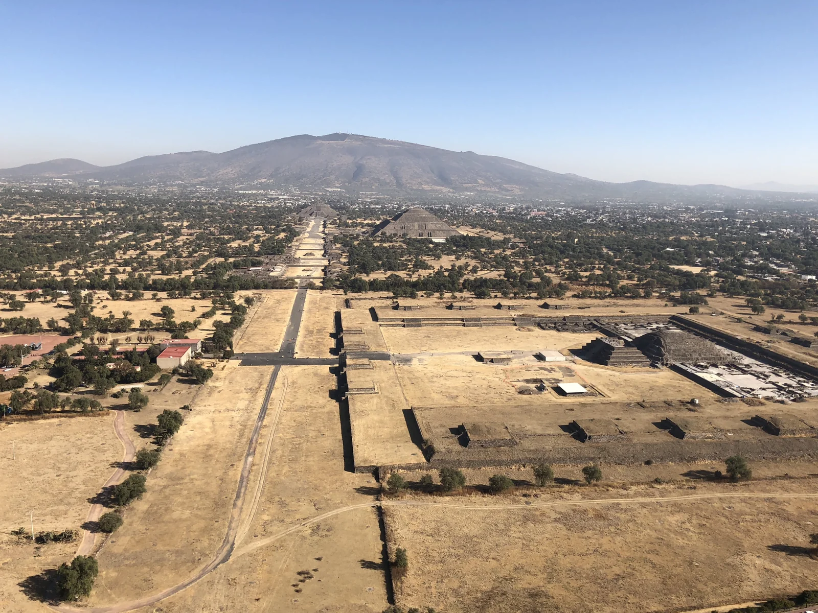
Elevated view of the Avenue of the Dead and the Pyramids of the Sun and Moon at Teotihuacan.
View across the Avenue of the Dead at Teotihuacan: the Pyramid of the Sun stands to the right, with the Pyramid of the Moon at the far end of the axis. Photograph taken on 27 December 2017. Ralibreros112 · CC BY-SA 4.0
The spaces between matter too.

Teotihuacan in present-day central Mexico became an important urban centre during the first centuries CE. Its plan connects monumental buildings with an extensive settlement. Source: UNESCO · Pre-Hispanic City of Teotihuacan

Through the centuries

No place stands still.

Choose a period. See how the story changes over time.

c. 150–225 CE

An avenue gives the city structure.

INAH dates the laying out of the Avenue of the Dead to this period of urban transformation. The broad axis connects major plazas and building complexes. Its familiar name comes from the Mexica, who interpreted the site differently centuries later.

Source

c. 150–225 CE

An avenue gives the city structure.

INAH dates the laying out of the Avenue of the Dead to this period of urban transformation. The broad axis connects major plazas and building complexes. Its familiar name comes from the Mexica, who interpreted the site differently centuries later.

Source: INAH · Calzada de los Muertos

During the city’s flourishing

Behind the monumental skyline.

Residential compounds such as Tetitla, Atetelco and Tepantitla also belong to Teotihuacan. Surviving murals broaden our understanding of its architecture. Looking only at the two great pyramids leaves out an important part of its archaeological record.

Source: INAH · Zona Arqueológica de Teotihuacán

7th century

The urban centre changes.

INAH describes decline in the later 7th century and discusses disruption of economic networks as one explanation. These processes cannot be reduced to a single event. An endpoint on a map simplifies a much longer development.

Source: INAH · Teotihuacan, guía del sitio

Look closer

A city builds on itself.

At the Superimposed Buildings, different construction levels remain visible. Floors and walls do not necessarily belong to the same moment. The exposed layers help us understand a city repeatedly changing its own form.

Today’s appearance combines surviving fabric, archaeological excavation and restoration. It is not a snapshot from one ancient year.

Source: INAH · Edificios Superpuestos
What to look for on a visit

Trace connections between a plaza, a stairway and a passage. Which movements do they allow, and where do they direct your gaze? A series of monuments becomes a readable urban space.

Reading the place

Beneath the surface.

Buildings and finds reveal more when we consider their context. These close readings connect the evidence with questions to take on a visit.

01

A floor separates moments in time.

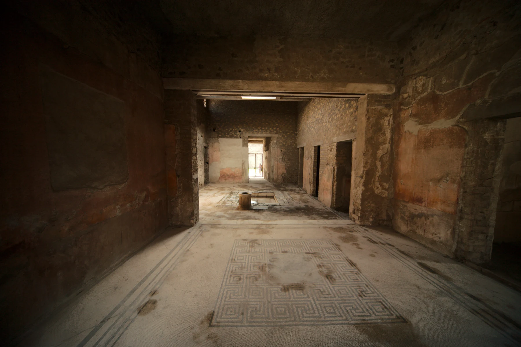
At the Edificios Superpuestos, earlier building levels remain visible beneath later ones. This part of the city was repeatedly built over.

Evidence / source: INAH · Edificios Superpuestos

Look at the relationship between a wall and a floor: does the wall continue below it, end at it, or cut through it later? Such relationships help establish a sequence. Assigning a calendar date is a further question. Archaeologists can know the order of alterations without dating each one to a single year.

What the evidence cannot establish on its own

A lower element is not automatically older simply because of its elevation. Later interventions can cut through earlier layers; dating requires the documented context.
02

What a later building conceals.

In the Ciudadela, the central pyramid predates the added Plataforma Adosada. The monumental ensemble contains different building phases even though it now appears as one connected space.

Evidence / source: INAH · La Ciudadela

Imagine the plaza without the later addition. Which façades would be more visible, and which routes more direct? This thought experiment is not a verified reconstruction of a visit. It does help explain how an addition can change an older monument’s character while parts of it remain intact.

What the evidence cannot establish on its own

Construction order alone does not securely identify the political intention behind a change. That requires further evidence and argument.

Plan a visit

Visit Teotihuacan with open eyes.

INAH describes several routes through the site. Choose according to your interests: monumental buildings, urban planning, or residential compounds and murals. Look for a tour that matches.

Check open areas, entrances and routes with the operator. A balloon flight is a different experience from a guided visit to the archaeological site; compare what is actually included.

Official visiting information ↗Instituto Nacional de Antropología e HistoriaGuided tours on GetYourGuide ↗Compare language, transport, admission and the actual itinerary in each offer.

Affiliate link: we may receive a commission when you book through GetYourGuide. The historical interpretation remains independent.

Visiting sources checked on 24 September 2026. Prices and availability are provided by the operator.

Continue your journey

See this time on the map →
Sources and context

These texts combine published research with editorial explanation. Some dates are approximate. Photographs show documented surviving conditions. Specialist archaeological review is still pending.

  1. Source: UNESCO · Pre-Hispanic City of Teotihuacan
  2. Source: INAH · Calzada de los Muertos
  3. Source: INAH · Zona Arqueológica de Teotihuacán
  4. Source: INAH · Teotihuacan, guía del sitio
  5. Source: INAH · Edificios Superpuestos
  6. Source: INAH · Explore Teotihuacán
Images and usage rights

View across the Avenue of the Dead at Teotihuacan: the Pyramid of the Sun stands to the right, with the Pyramid of the Moon at the far end of the axis. Photograph taken on 27 December 2017. Ralibreros112 / Wikimedia Commons · CC BY-SA 4.0. Resized to a maximum edge of 1600 pixels and compressed as WebP; no crop or content alterations. Framing varies by screen. Derived photograph under the same licence.

Barlow OFL · Manrope OFL