Angkor Wat Map: Plan of the Temples of Angkor
Our own Angkor temples map with 20 highlights: Angkor Wat and its moat, Phnom Bakheng, the city of Angkor Thom with the Bayon and the royal terraces, Ta Keo, Ta Prohm and Banteay Kdei along the Small Circuit. Tap a number for details, choose a route or print the map for your visit.
Map of Angkor Wat, Angkor Thom and the Small Circuit
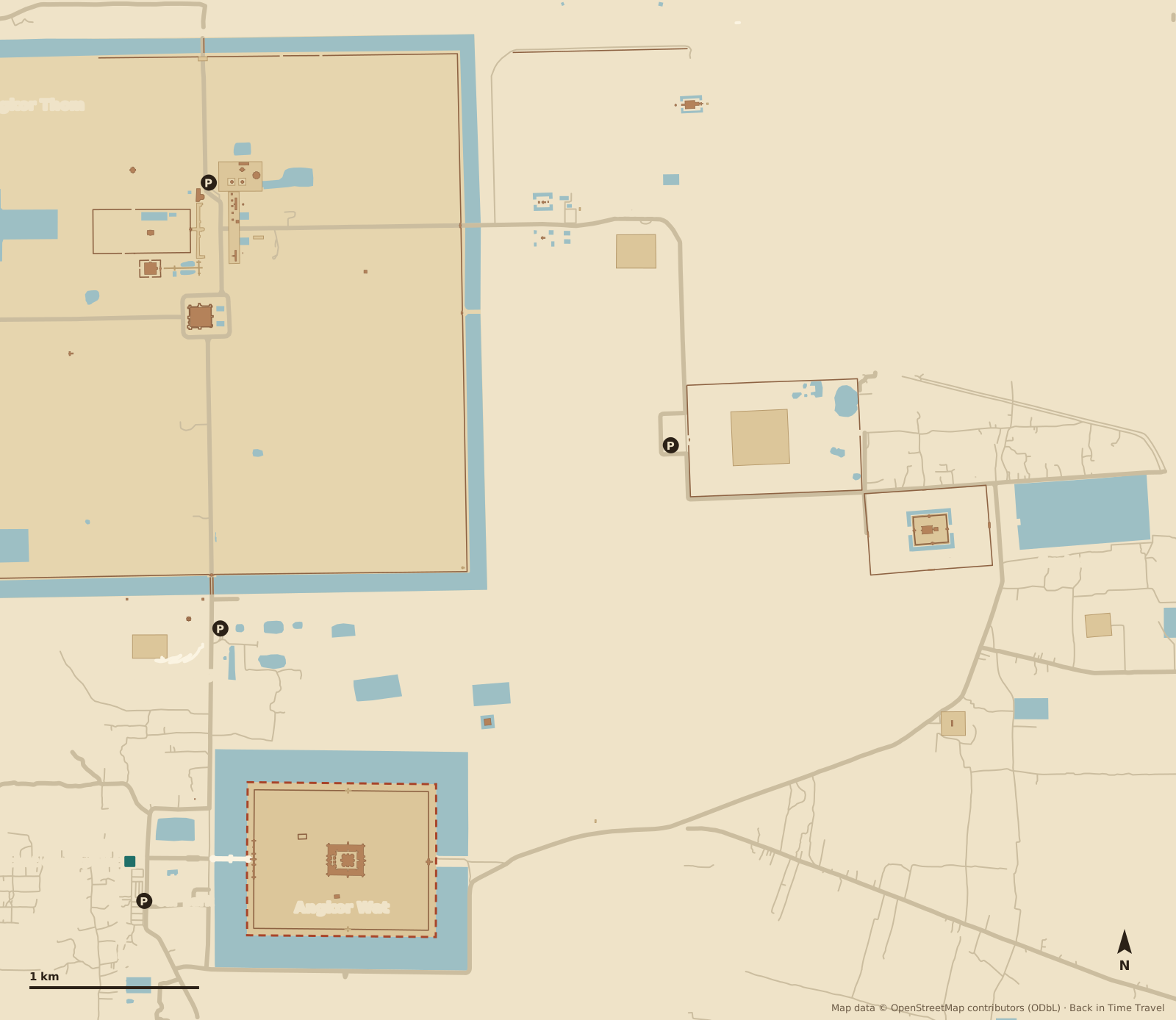
Map data © OpenStreetMap contributors, ODbL. Drawn by Back in Time Travel, data as of 25 September 2026. The map is a guide; paths, the one-way route through Ta Prohm and closed areas can change. The temples of the Grand Circuit lie north and east beyond the edge of the map.
The 20 highlights on the map
The numbers match the map. The order follows the Small Circuit clockwise: from the ticket checkpoint at the west causeway through Angkor Wat, up Phnom Bakheng and through the South Gate into Angkor Thom, out through the Victory Gate to Ta Keo and Ta Prohm, then back via Banteay Kdei, Srah Srang and Prasat Kravan.
Ticket checkpoint and west causeway Entrance
Here the road from Siem Reap meets the 190-metre-wide moat. Staff check the Angkor Pass (buy it in advance at the ticket centre or online, not here). Beyond it the sandstone causeway crosses the moat to the west gate; it was restored with Japanese help until 2023.
Read more →West gate Gopura of the outer wall
The western gatehouse in the outer enclosure wall, with three towers and long galleries to north and south. In the southern tower stands the eight-armed Vishnu statue Ta Reach, venerated today as a guardian spirit; it probably once stood in the central tower of the temple.
Angkor Wat, central sanctuary Temple mountain
Five towers shaped like lotus buds on three levels, the central one 65 metres above the ground. Built in the first half of the 12th century under Suryavarman II as a temple to Vishnu and probably as his tomb, hence facing west. The top level (Bakan) is open to a limited number of visitors at a time, shoulders and knees covered, no children under twelve.
Read more →Bas-relief galleries Outer gallery
The gallery around the lowest level carries the longest bas-reliefs in Khmer art: in the east the Churning of the Ocean of Milk, in the west the Battle of Kurukshetra from the Mahabharata, in the south the army of Suryavarman II and the heavens and hells. Walk anticlockwise, the direction in which the scenes are meant to be read.
North pond Sunrise
The left of the two ponds in front of the temple, in which the five towers are reflected: the classic sunrise spot, crowded from 5 am. The sun rises behind the temple, exactly over the central tower only around the equinoxes in March and September. There is more room further south or by the library.
Phnom Bakheng Temple mountain on the hill
The state temple of Yasovarman I from around 900 on a hill some 60 metres high, the centre of the first capital Yasodharapura: five tiers, once 108 towers. Famous for the sunset over Angkor Wat, and therefore limited to 300 visitors at a time; arrive by 4 pm. The climb is on foot along the forest path, about 15 minutes.
Read more →South Gate of Angkor Thom City gate
The best preserved of the five gates, 23 metres high, with four faces towards the cardinal points. The causeway across the moat is lined by 54 gods on the left and 54 demons on the right holding the naga serpent: the Churning of the Ocean of Milk in stone. Beyond lies the 3 by 3 kilometre city of Jayavarman VII, founded around 1181.
Read more →Bayon State temple
The temple of Jayavarman VII at the centre of Angkor Thom, around 1200: 37 surviving towers with more than 200 huge smiling faces, read as the bodhisattva Lokeshvara or as the king himself. The outer gallery shows everyday life, markets, cockfights and the naval battle against the Cham on the Tonlé Sap.
Read more →Baphuon Temple mountain
The Shiva temple of Udayadityavarman II from around 1060, three tiers high, approached by a 200-metre causeway on pillars. In the 16th century the west side was rebuilt into a 70-metre reclining Buddha. Reconstructed from 1960 to 2011 after 300,000 numbered stones lost their plans in the civil war.
Phimeanakas and Royal Palace Palace enclosure
A small laterite pyramid inside the walled palace enclosure, around 1000. According to legend the king had to sleep in the tower every night with a naga princess, or disaster would strike the kingdom. Nothing remains of the wooden palace itself, only walls, gates and the bathing ponds of Srah Srei.
Terrace of the Elephants Royal grandstand
The 300-metre grandstand in front of the palace, decorated with life-size elephants, garudas and lions. From here the court watched parades and festivals on the great square; Zhou Daguan described fireworks and processions in 1296. Opposite stand the twelve towers of Prasat Suor Prat.
Terrace of the Leper King Platform
A platform with the statue of a seated god, probably Yama, lord of the dead, popularly known as the Leper King (the original is in the National Museum in Phnom Penh). Inside, a hidden passage runs past seven tiers of reliefs of nagas, demons and apsaras, uncovered during restoration.
Prasat Suor Prat and the Khleangs Towers on the square
Twelve laterite towers in a row opposite the Terrace of the Elephants, early 13th century. According to Zhou Daguan they served to settle disputes: both parties had to sit in a tower for days, and whoever fell ill was in the wrong. Behind them are the Khleangs, two long halls of the 10th and 11th centuries.
Victory Gate City gate
The eastern gate on the royal axis, 500 metres north of the Gate of the Dead, with the same face towers and naga balustrades as the South Gate but far quieter. The road east leads to Thommanon, Chau Say Tevoda and Ta Keo; this is where the Small Circuit leaves the city.
Thommanon and Chau Say Tevoda Two small temples
Two almost identical temples in the Angkor Wat style, early 12th century, facing each other across the road from the Victory Gate. Thommanon to the north is well preserved with fine devata figures; Chau Say Tevoda to the south was rebuilt with Chinese help from 2000 to 2009.
Ta Keo Unfinished temple mountain
The first temple built entirely of sandstone, around 1000 under Jayavarman V: five towers on a 22-metre pyramid but hardly any decoration, because work stopped, according to legend after a lightning strike. The stairs are very steep. To the north, Ta Nei lies hidden in the forest.
Ta Prohm Monastery temple in the jungle
The monastery of Rajavihara, founded in 1186 by Jayavarman VII for his mother; its foundation inscription says 12,640 people served the temple. Deliberately left as it was found: strangler figs and tetrameles trees grip the galleries. Filming location of “Tomb Raider”. One-way route from the west to the east gate; quietest early morning or late afternoon.
Read more →Banteay Kdei Monastery temple
The “citadel of cells”, a Buddhist monastery of Jayavarman VII from the late 12th century, similar to Ta Prohm but smaller and usually almost empty. Four face gates and a hall of dancers with apsara reliefs; in 2001, 274 buried Buddha statues were found here, now in the museum in Siem Reap.
Srah Srang Royal bath
A reservoir of 700 by 350 metres from the 10th century, given sandstone steps and a landing terrace with naga balustrades and lions under Jayavarman VII. Opposite Banteay Kdei; a quiet spot for sunrise without the crowds of Angkor Wat.
Prasat Kravan Brick temple
Five brick towers in a row, consecrated in 921, a Vishnu temple of high officials. Unique at Angkor are the reliefs carved into the brick inside: Vishnu with eight arms and striding across the ocean in the central tower, his consort Lakshmi in the north tower. The last stop on the Small Circuit before returning to Angkor Wat.
Routes through Angkor
Three suggestions. Choose a route and its stops are highlighted on the map. The park opens at 5 am (Angkor Wat, Srah Srang, Phnom Bakheng) or 7.30 am; the heat sets in around 10 am, so water and a hat are essential.
The Small Circuit in one day
All 20 stops clockwise by tuk-tuk or bicycle, about 17 kilometres: Angkor Wat early, Angkor Thom in the morning, a break at midday, Ta Keo, Ta Prohm and Banteay Kdei in the afternoon, back via Prasat Kravan for sunset. Ten to twelve hours.
- 1 Ticket checkpoint and west causeway
- 2 West gate
- 3 Angkor Wat, central sanctuary
- 4 Bas-relief galleries
- 5 North pond
- 6 Phnom Bakheng
- 7 South Gate of Angkor Thom
- 8 Bayon
- 9 Baphuon
- 10 Phimeanakas and Royal Palace
- 11 Terrace of the Elephants
- 12 Terrace of the Leper King
- 13 Prasat Suor Prat and the Khleangs
- 14 Victory Gate
- 15 Thommanon and Chau Say Tevoda
- 16 Ta Keo
- 17 Ta Prohm
- 18 Banteay Kdei
- 19 Srah Srang
- 20 Prasat Kravan
Sunrise and Angkor Wat alone in 3 hours
At the ticket checkpoint at 5 am, across the causeway and through the west gate in the dark to the north pond. After sunrise, follow the bas-reliefs anticlockwise, then climb to the central sanctuary before the coach groups arrive at 9 am.
The Grand Circuit as a second day
Through the South Gate to the Bayon and the terraces, then out through the North Gate to Preah Khan, Neak Pean, Ta Som, East Mebon and Pre Rup, which lie north and east beyond this map (Preah Khan is 1.5 kilometres north of the North Gate). Back via Srah Srang and Prasat Kravan, about 26 kilometres.
Entrance, ticket checkpoint and car parks
- Ticket checkpoint at the west causeway
- Where the road from Siem Reap meets the moat of Angkor Wat, staff check the Angkor Pass; it is checked again at every temple. It is not sold here, only at the Angkor Ticket Centre on Road 60 on the edge of Siem Reap or online. Without a pass you cannot cross the causeway.
- Angkor Wat car park
- South of the road, opposite the ticket checkpoint, with stalls, food shacks and toilets. The tuk-tuk drivers wait here, and day tours drop you at the same place. The causeway across the moat starts 200 metres further east.
- Other car parks
- At the foot of Phnom Bakheng, outside the west entrance of Ta Prohm and by the Terrace of the Leper King in Angkor Thom (all marked P). Drivers wait while you visit the temples; that is included in the tuk-tuk price.
- Getting between the temples
- The Small Circuit is about 17 kilometres long, too far to walk. Most people take a tuk-tuk (daily rate), a bicycle or an e-bike; the park roads have a 40 km/h limit and are shaded by trees almost everywhere.
Angkor Pass prices, opening hours, the dress code and the ticket centre are in our guide Angkor Wat tickets and admission.
Where is Angkor Wat?
Angkor Wat lies in north-western Cambodia in Siem Reap province, six kilometres north of the town of Siem Reap and about 15 kilometres from the northern shore of Tonlé Sap lake. The temple is the southernmost part of the Angkor Archaeological Park, which extends north and east with Angkor Thom and the temples of the two circuits. Distances from the central sanctuary, as the crow flies:
- Siem Reap (centre)
- 6 km
- Siem Reap-Angkor Airport (SAI)
- 39 km
- Phnom Penh
- 236 km
- Battambang
- 80 km
- Bangkok
- 366 km
Frequently asked questions about the Angkor map
Where is Angkor Wat?
Angkor Wat lies in Siem Reap province in north-western Cambodia, 6 kilometres north of the centre of Siem Reap as the crow flies (seven kilometres by road, 15 to 20 minutes by tuk-tuk) and 39 kilometres as the crow flies from Siem Reap-Angkor Airport (SAI), which is about 40 kilometres by road east of the town, just under an hour’s drive. Phnom Penh is 236 kilometres away as the crow flies, about 320 kilometres and five to six hours on National Road 6; Battambang lies 80 kilometres to the south-west, Bangkok 366 kilometres to the west.
How big is Angkor?
The Angkor Archaeological Park covers about 400 square kilometres. Our map shows the core: Angkor Wat with its moat measures 1.5 by 1.3 kilometres, Angkor Thom 3 by 3 kilometres, and the Small Circuit linking them with Ta Keo, Ta Prohm and Banteay Kdei is about 17 kilometres long. That is too far to walk; you need a tuk-tuk, a bicycle or an e-bike. Allow two to three hours for Angkor Wat alone and a full day for the Small Circuit.
Is there a printable Angkor Wat map?
Yes: use the “Print map or save as PDF” button on this page. It prints the map, the highlights and the routes. In the park there are information boards at the main temples but no printed plans; the tuk-tuk drivers know the circuits by heart.
Small Circuit or Grand Circuit?
The Small Circuit (Petit Circuit, 17 kilometres) takes in the most famous temples: Angkor Wat, Phnom Bakheng, Angkor Thom with the Bayon, Ta Keo, Ta Prohm and Banteay Kdei. The Grand Circuit (26 kilometres) adds Preah Khan, Neak Pean, Ta Som, East Mebon and Pre Rup to the north and east, quieter and smaller. With one day take the Small Circuit; with three days do both plus Banteay Srei, 35 kilometres to the north-east.
How far is it from Siem Reap to Angkor Wat?
About six kilometres from the town centre as the crow flies, seven kilometres by road, 15 to 20 minutes by tuk-tuk or half an hour by bicycle. Buy the Angkor Pass beforehand at the ticket centre on Road 60 on the edge of town or online, because there is no sales point at the checkpoint on the west causeway.
Where is the best place for sunrise?
At the north pond in front of Angkor Wat, where the five towers are reflected; be at the ticket checkpoint at 5 am. If you dislike crowds, go to the south pond, to the landing terrace of Srah Srang or into the temple itself, which is still empty at that hour. For sunset go to Phnom Bakheng (limited to 300 people) or Pre Rup on the Grand Circuit.
Can you climb Angkor Wat?
Yes, the top level (Bakan) is reached by a steep wooden staircase, with a limited number of visitors at a time and queues in the morning. Shoulders and knees must be covered, children under twelve are not allowed up, and the Bakan is closed on Buddhist holy days. At Ta Keo and Pre Rup you can climb the pyramids, at the Bayon the upper terrace.