Chichen Itza Map: Plan of the Maya Ruins
Our own plan of Chichén Itzá with 19 highlights, El Castillo, the Great Ball Court, the Sacred Cenote, the Temple of the Warriors, Old Chichén with the Caracol and Las Monjas, the entrance and the new museum. Tap a number for details, choose a route or print the map for your visit.
Map of the Maya city of Chichén Itzá
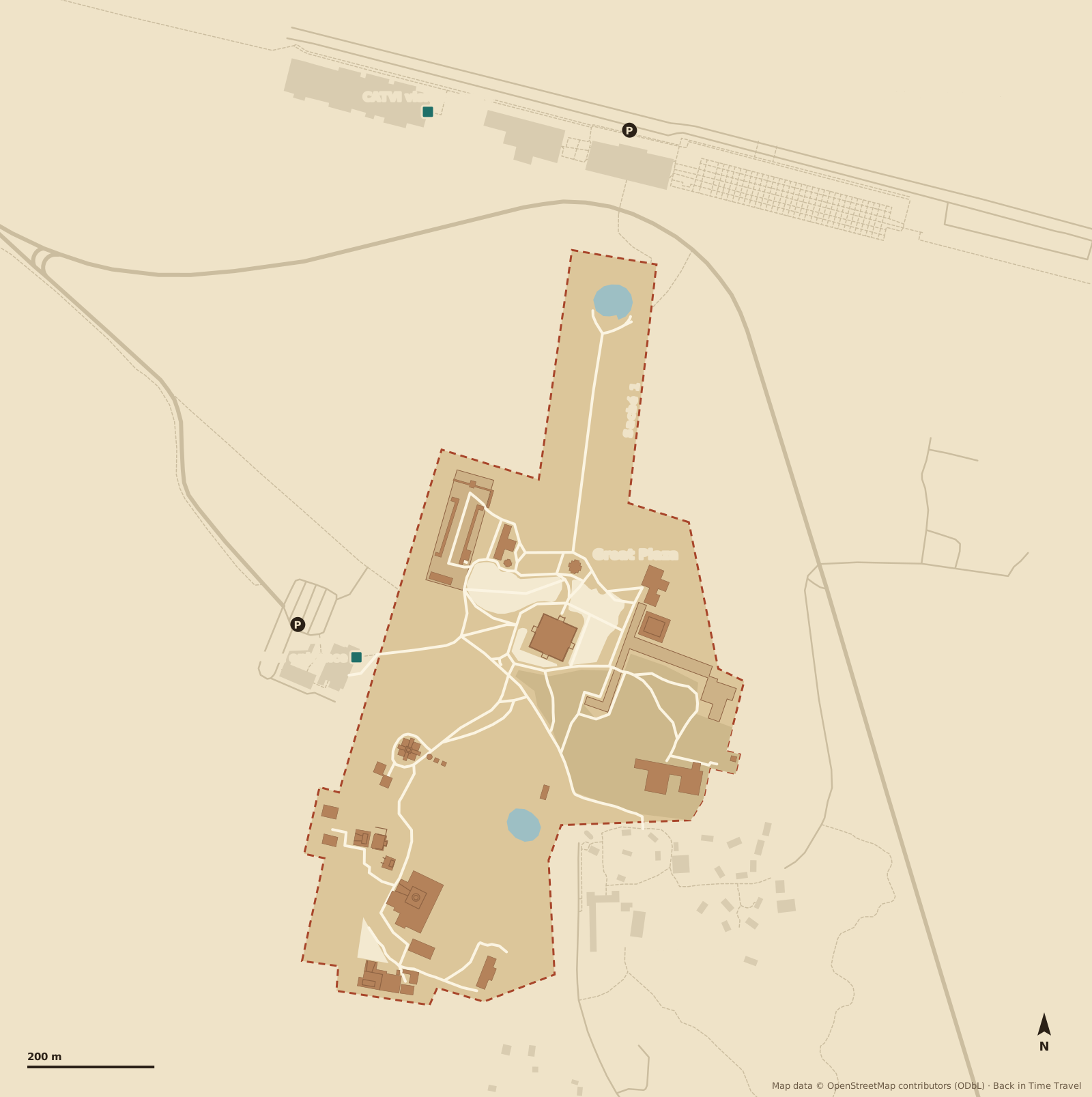
Map data © OpenStreetMap contributors, ODbL. Drawn by Back in Time Travel, data as of 25 September 2026. The map is a guide; paths, closures and access points can change.
The 19 highlights on the map
The numbers match the map. The order follows a circuit from the main entrance in the west past the Great Ball Court and the platforms to the Sacred Cenote, El Castillo and the Temple of the Warriors, then south via Cenote Xtoloc to Old Chichén with the Osario, the Caracol and Las Monjas, and finally the museum at the visitor centre.
Main entrance Parador Turístico
The entrance in the west on the old Highway 180: ticket desks, toilets, lockers, restaurants and the craft market are in the Parador Turístico, with the car park, taxi rank and the ADO and Oriente bus stop outside. From here it is 300 metres to the Great Ball Court.
Read more →Great Ball Court Juego de Pelota
At 168 metres long the largest ball court in Mesoamerica. The stone rings hang eight metres up on the side walls, and the reliefs at their base show the beheading of a player. A whisper at one end can be heard at the other.
Temple of the Jaguars Templo de los Jaguares
On the east wall of the ball court, with serpent columns and a jaguar frieze: the upper temple faces the playing field, the lower one with its jaguar throne faces the plaza. The murals inside show a battle.
Tzompantli Skull platform
A T-shaped platform whose sides are carved with rows of skulls. The heads of sacrificial victims were displayed here on poles, a building modelled on Tula in central Mexico.
Platform of the Eagles and Jaguars Plataforma de las Águilas y los Jaguares
A small platform with stairways on all four sides. The reliefs show eagles and jaguars devouring human hearts, the emblems of the two warrior orders.
Venus Platform Plataforma de Venus
The square platform at the start of the sacbé to the Sacred Cenote, with reliefs of the planet Venus and the Feathered Serpent. From here the 300-metre processional way leads north.
Sacred Cenote Cenote Sagrado
A round sinkhole 60 metres across, its walls dropping 20 metres sheer to the water. Here the Maya threw jade, gold, copal and people as offerings to the rain god Chaac. Edward Thompson dredged the bottom from 1904; some of the finds are now in the museum.
Read more →El Castillo Pyramid of Kukulcán
The landmark of Chichén Itzá: 30 metres high, nine terraces, four stairways of 91 steps each, 365 with the top platform. At the equinoxes the north-west edge casts a serpent pattern onto the stairway. Inside is an older pyramid with a jaguar throne; climbing has been banned since 2006.
Read more →Temple of the Warriors Templo de los Guerreros
A stepped pyramid with a Chac Mool figure and serpent columns on its platform, fronted by rows of pillars carved with warriors. Its model stands at Tula; the building dates from the 10th or 11th century.
Group of the Thousand Columns Grupo de las Mil Columnas
Colonnaded halls around a wide plaza south of the Temple of the Warriors. They once carried roofs of timber and stucco and were probably the assembly and administrative halls of the city.
El Mercado Colonnaded hall
A long building at the southern end of the Thousand Columns with a courtyard surrounded by tall slender columns. The name “market” comes from early explorers; it was probably a council hall. A steam bath stands next to it.
Cenote Xtoloc The city’s drinking water
The second large cenote, from which the city drew its drinking water, with a small temple on its rim. A sacbé links it to the plaza around El Castillo; the path south to the Osario passes it.
El Osario High Priest’s Grave
A smaller version of El Castillo, ten metres high, with a shaft leading from the top into a natural cave with seven burials. An inscription gives the year 998. Around it are small platforms and a sacbé to Cenote Xtoloc.
Casa Colorada Chichanchob
One of the best-preserved buildings in the city, on a platform, with a roof comb. The hieroglyphic text inside names the year 869 and rulers of the city. Next to it is a small ball court.
El Caracol Observatory
A round tower on two platforms, named after its spiral staircase. The windows in the upper storey are aligned with the extreme positions of Venus; from here the priests watched the sky. Around AD 900.
Read more →Las Monjas The Nunnery
A Puuc-style palace on a massive base, enlarged in several phases. The east annex carries a facade made up entirely of Chaac masks; the Spaniards took the building for a convent.
La Iglesia The Church
A small building next to Las Monjas with a lavish facade: Chaac masks, the four Bacabs who hold up the sky and a high roof comb. The photographers’ favourite in Old Chichén.
Akab Dzib House of the Dark Writing
A long building with 18 rooms, named after the lintel with hieroglyphs above the door of an inner room. The inscription dates from around AD 870. From here the path leads back north to the entrance.
Gran Museo de Chichén Itzá CATVI visitor centre
The museum opened in 2024 in the visitor centre north of the zone shows about a thousand finds, including offerings from the Sacred Cenote and pieces from Chichén Viejo. Shuttles from the Tren Maya station end here; a footpath connects the centre with the northern edge of the zone.
Read more →
Routes through Chichén Itzá
Three suggestions, all from the main entrance. Choose a route and its stops are highlighted on the map. There is shade only on the paths between the groups; water and a hat are essential.
The highlights in 2 hours
From the main entrance to the Great Ball Court, past the Tzompantli and the Venus Platform to El Castillo, on to the Temple of the Warriors and the Thousand Columns, and finally along the sacbé to the Sacred Cenote and back.
The whole day with Old Chichén
All 19 stops: the northern group in the morning, then via Cenote Xtoloc to the Osario, the Caracol and the Puuc buildings around Las Monjas, where it is much quieter. Five to six hours with breaks; finish with the museum at the visitor centre.
- 1 Main entrance
- 2 Great Ball Court
- 3 Temple of the Jaguars
- 4 Tzompantli
- 5 Platform of the Eagles and Jaguars
- 6 Venus Platform
- 7 Sacred Cenote
- 8 El Castillo
- 9 Temple of the Warriors
- 10 Group of the Thousand Columns
- 11 El Mercado
- 12 Cenote Xtoloc
- 13 El Osario
- 14 Casa Colorada
- 15 El Caracol
- 16 Las Monjas
- 17 La Iglesia
- 18 Akab Dzib
- 19 Gran Museo de Chichén Itzá
Early at 8 am, before the coach groups
Straight to El Castillo at opening time while the plaza is empty, then the Sacred Cenote, the ball court and the Temple of the Warriors. By the time the coaches from Cancún arrive around 10 am you are already in the south at the Osario, the Caracol and Las Monjas.
Entrance, visitor centre and car parks
- Main entrance (Parador Turístico)
- In the west on the old Highway 180, two kilometres east of Pisté. Ticket desks, toilets, lockers, restaurants and the craft market are in the Parador; the ADO and Oriente buses, colectivos to Valladolid and taxis stop right outside. The zone opens at 8 am, last entry 4 pm.
- CATVI visitor centre with Gran Museo
- In the north on the Highway 180 bypass: the Gran Museo de Chichén Itzá, opened in 2024, a craft market and the large INAH car park. Shuttles from the Tren Maya station, about four kilometres to the north-east, end here. A footpath leads to the northern edge of the zone at the Sacred Cenote; whether you can enter there varies, so head for the main entrance if in doubt.
- Car parks
- A paid car park right at the main entrance, full from late morning, and the INAH car park at the CATVI with 700 spaces. The hotels on the east side of the zone (Mayaland, Hacienda Chichén, Villas Arqueológicas) have their own parking for guests.
Prices, opening hours and how to get there by bus, car or Tren Maya are in our guide Chichen Itza tickets and admission.
Where is Chichen Itza?
Chichén Itzá lies in the east of the Mexican state of Yucatán, halfway between Mérida and Cancún, on the old Highway 180 by the village of Pisté and 40 kilometres west of Valladolid. By road it is about 200 kilometres from Cancún on the 180D motorway, a good two hours; from Mérida about 120 kilometres. Distances from El Castillo, as the crow flies:
- Cancún
- 186 km
- Playa del Carmen
- 156 km
- Tulum
- 126 km
- Mérida
- 111 km
- Valladolid
- 38 km
Frequently asked questions about the Chichen Itza map
Where is Chichen Itza?
Chichén Itzá lies in the east of the state of Yucatán in Mexico, by the village of Pisté on the old Highway 180. As the crow flies it is 38 kilometres to Valladolid, 111 kilometres to Mérida, 186 kilometres to Cancún, 156 kilometres to Playa del Carmen and 126 kilometres to Tulum. By road it is about 200 kilometres from Cancún (180D motorway, a good two hours) and about 120 kilometres from Mérida. The nearest airports are Cancún and Mérida; the Tren Maya stops about four kilometres north-east of the zone.
How big is Chichen Itza?
The accessible zone measures a good kilometre from the Sacred Cenote in the north to Las Monjas in the south and about 700 metres across; the city with its residential districts was far larger. From the entrance to El Castillo is a good 300 metres, to the Sacred Cenote another 500, and to Old Chichén about 600 metres south. The highlights take two hours, all 19 stops five to six.
Is there a printable Chichen Itza map?
Yes: use the “Print map or save as PDF” button on this page. It prints the map, the highlights and the routes. There is also an information board at the main entrance, and the paths in the zone are signposted.
Can you climb El Castillo?
No. The pyramid has been closed since 2006, as have all the other buildings in the zone; anyone who climbs anyway risks a fine and arrest. The best view is from the plaza in front early in the morning, when the sun lights the north stairway.
When is Chichen Itza least crowded?
At 8 am when it opens. The day trips from Cancún, Playa del Carmen and Tulum arrive between 10 and 11 am and stay until early afternoon. If you stay overnight in Valladolid, Pisté or one of the hotels by the zone, you have the first hour almost to yourself. At the equinoxes in March and September it is busier than at any other time.
How do I get from Cancún to Chichen Itza?
By car on the 180D toll motorway, about 200 kilometres, a good two hours. By ADO bus from Cancún or Valladolid directly to the main entrance. By Tren Maya to Chichén Itzá station and from there by shuttle to the visitor centre. Day tours pick you up at your hotel and usually combine the zone with a cenote and Valladolid.
What is Old Chichén?
The southern part of the zone around the Osario, the Caracol, Las Monjas, the Iglesia and Akab Dzib, built in the Puuc style of the 9th century and older than the grand buildings in the north. Further south lies Chichén Viejo with the Initial Series Group, open since 2023 only in small groups with limited access; ask at the ticket desk for the current arrangements.