Pyramids of Giza map: plan of the plateau
Our own plan of the Giza plateau with 20 highlights: the three pyramids with their queens’ pyramids, the mastaba fields to the west and east, the Sphinx and valley temple, the causeways, the tomb of Meresankh, the panoramic viewpoint with the camel stand, plus the new main entrance on the Fayoum road, the Sphinx entrance and the electric bus stops. Tap a number for details, choose a route, or print the map for your visit.
Map of the Giza pyramid plateau
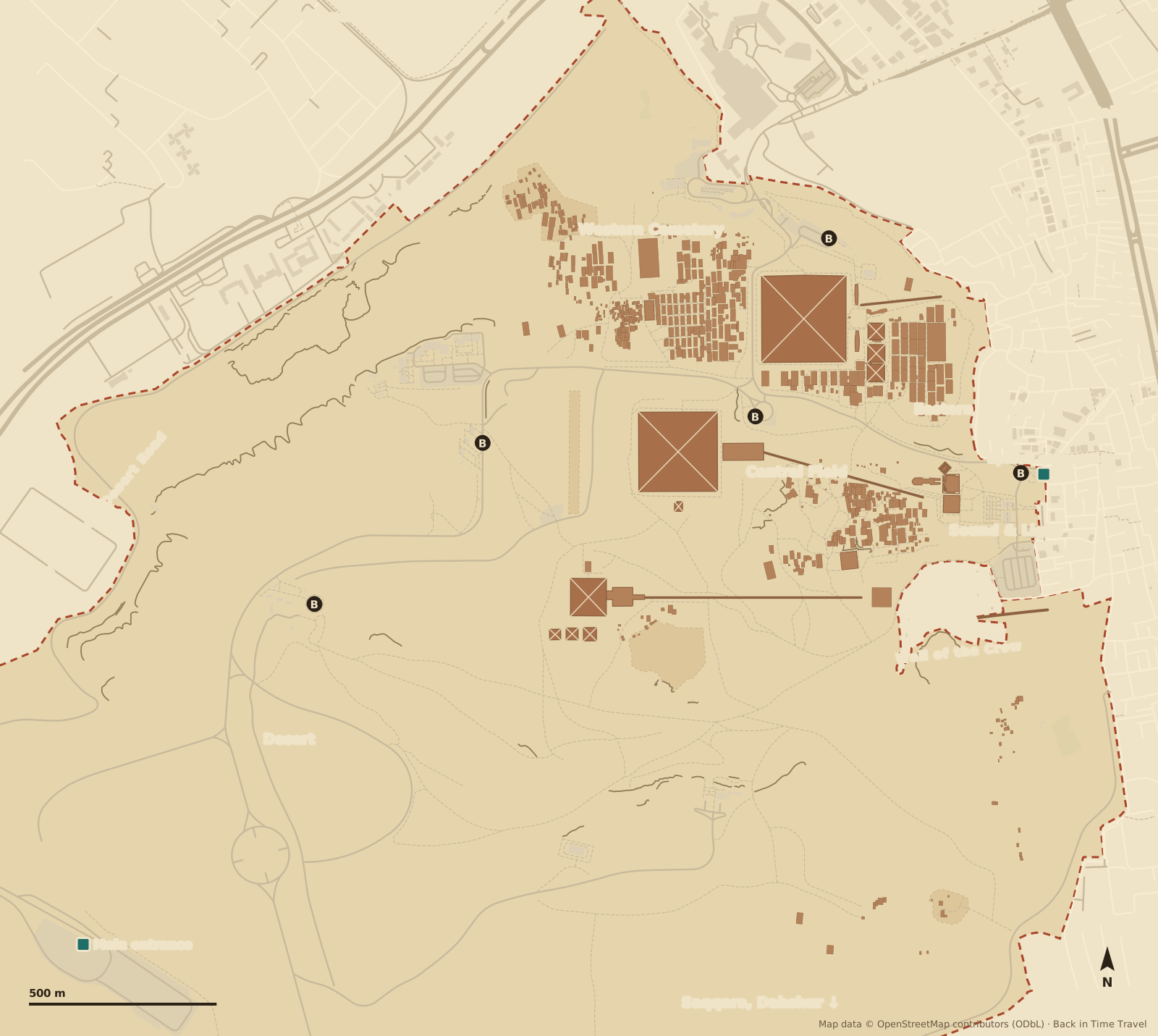
Map data © OpenStreetMap contributors, ODbL. Drawn by Back in Time Travel, data as of 25 September 2026. The map is a guide to orientation; entrances, bus routes and closures have changed frequently since the plateau was redeveloped, and the signs on site apply.
The 20 highlights on the map
The numbers match the map. The order follows the classic walk from the Sphinx entrance past the valley temple and the Sphinx up the causeway to Khafre and Khufu, then west through the cemeteries to Menkaure, to the panoramic viewpoint in the south, to Khentkawes and the workers’ cemetery, and finally to Mena House on the northern edge.
Main entrance and visitor centre Cairo–Fayoum desert road
Since 2025 the entrance for everyone arriving by car, taxi or coach: ticket desks and machines, security screening, an exhibition with replicas, toilets, cafés and a car park for 2,000 vehicles. Vehicles stay here; the electric buses take you up onto the plateau in a few minutes. Opens 8 am, last entry 4 pm.
Read more →Sphinx entrance Nazlet el-Samman, no ticket desk
The pedestrian entrance on the eastern edge, between the valley temple and the Sound and Light arena. No ticket desk any more: only with an online ticket bought in advance. From here it is 200 metres to the Sphinx and a good kilometre uphill to the Great Pyramid; the “Sphinx” bus stop is right next to it.
Read more →Valley temple of Khafre Granite pillars and alabaster floor
The best-preserved temple on the plateau: walls of limestone blocks faced with polished Aswan granite, monolithic pillars, a floor of alabaster. Here the king’s body was prepared for burial, and here stood the diorite statue of Khafre with the Horus falcon at his neck, now in the museum. The passage leads on to the causeway.
Sphinx Temple In front of the paws of the Sphinx
A court with 24 pillars directly in front of the Sphinx, built from the very blocks quarried when the Sphinx was cut from the rock. The temple was never finished and was buried in sand as early as the Old Kingdom; you see it from the terrace of the valley temple. Two niches for sunrise and sunset point to a sun cult.
Great Sphinx 73 metres long, 20 metres high
A lion’s body with the head of a king, carved from the living rock of the plateau, probably under Khafre. Between the paws stands the Dream Stele of Thutmose IV, who freed the Sphinx from the sand a thousand years later. The view from the terrace between the valley temple and the Sphinx Temple is the classic one; the Sphinx itself cannot be approached. Our story of Khufu’s building site begins here.
Read more →Causeway of Khafre Ramp from the valley to the mortuary temple
For almost 500 metres the covered way climbs from the valley temple diagonally up to the mortuary temple at the pyramid; along it went the king’s funeral procession. The causeways of the three pyramids run in parallel; Khufu’s now lies beneath the houses of Nazlet el-Samman. The path beside the causeway is the direct climb from the Sphinx to the great pyramids.
Mortuary temple of Khafre At the foot of the east side
A pillared court, five statue niches and storerooms, built from blocks of several hundred tonnes: the place of the funerary cult, where offerings were made every day. From the temple the causeway leads down to the valley; from the terrace in front you have the pyramid of Khafre directly above you and the Great Pyramid to the north.
Pyramid of Khafre 136 metres, casing still at the top
The second pyramid, only a few metres lower than Khufu’s, stands on higher rock and so looks bigger. At the top the smooth Tura limestone casing that once covered all three pyramids still clings on. Inside a simple passage leads to the burial chamber with the sarcophagus; separate ticket, usually no queue.
Great Pyramid of Khufu Pyramid of Cheops, 146.6 metres, now 138.8
The oldest of the Seven Wonders and the only one still standing: 230 metres a side, some 2.3 million blocks, built in a good 20 years around 2560 BC. The way in is the robbers’ tunnel of Caliph al-Ma’mun on the north side; inside are the Grand Gallery and the granite King’s Chamber. Separate ticket, daily quota, no photos inside.
Read more →Boat pits of Khufu Solar boat, now in the Grand Egyptian Museum
Five pits around the pyramid; two held dismantled boats of cedar wood. The 43-metre barque, discovered in 1954, stood until 2021 in the boat museum on the south side of the pyramid; the museum has been dismantled and the boat, together with the second one recovered only in 2021, is now in the Grand Egyptian Museum two kilometres to the north. The empty pits with their cover blocks can still be seen.
Read more →Queens’ pyramids of Khufu and Eastern Cemetery G I-a to G I-c, mastabas of the royal family
Three small pyramids on the east side for the king’s mother Hetepheres I and the queens Meritites and Henutsen, plus the remains of the cult pyramid. Behind them begins the Eastern Cemetery with the great double mastabas of Khufu’s sons and daughters: Kawab, Khufukhaf, Meresankh. From here you look out over Nazlet el-Samman to the Nile valley.
Tomb of Meresankh III G 7530, rock-cut tomb with paintings
The finest tomb you can enter at Giza: granddaughter of Khufu, wife of Khafre. Three rock-cut rooms with coloured reliefs of daily life, rows of statues of ten women of the family and a shaft to the burial chamber with the granite sarcophagus. Open since 2012, separate ticket, small groups; the guard leads the way with a torch.
Read more →Western Cemetery and mastaba of Hemiunu Streets of tombs
West of the Great Pyramid the mastabas of the officials lie in straight rows like city blocks, each a tomb with a cult chapel and a shaft. The largest is G 4000, the tomb of Hemiunu, vizier and probably architect of the Great Pyramid; his seated statue is in Hildesheim. Some tombs are open, such as those of Iymery and Seshemnefer, with reliefs of harvest, cattle and fishing.
Pyramid of Menkaure 65 metres, granite casing below
The smallest of the three royal pyramids, a tenth of the mass of Khufu’s, but faced in its lowest 16 courses with red granite. The gash in the north face dates from 1196, when Saladin’s son tried to have the pyramid demolished and gave up after eight months. Inside are chambers with niche decoration; separate ticket, often closed in alternation with Khafre.
Queens’ pyramids of Menkaure G III-a to G III-c
Three small pyramids on the south side: the eastern one a true pyramid, probably the cult pyramid, the other two step pyramids that were never finished. They stand free in the sand, unfenced, and with the great pyramid behind them make the picture of the desert side of the plateau.
Panoramic viewpoint and camel stand All three pyramids in a row
The hill in the south from which all three pyramids with their queens’ pyramids line up one behind the other: the photo most people come for, best in the morning with the sun behind you. This is where the camel and horse handlers wait and where the 9 Pyramids Lounge restaurant stands; the electric buses stop below. Agree the price for a camel beforehand, including the way back.
Western viewpoint First stop of the electric buses
The terrace on the western edge of the plateau, 93 metres up, with cafés and toilets: the first stop of the buses from the visitor centre, looking across the desert to the back of the pyramids of Khafre and Menkaure. From here a desert path leads on foot to the panoramic viewpoint and the pyramid of Menkaure, half an hour through sand.
Tomb of Khentkawes I The “fourth pyramid”
A cube of rock with a masonry superstructure, for the queen who at the end of the 4th Dynasty was mother of two kings. Below, a block of limestone left standing by the quarries; above, a mastaba-like building; in front, the houses of her funerary priests. Between the causeway of Khafre and the Wall of the Crow, in the middle of the Central Field of rock-cut tombs.
Workers’ cemetery Behind the Wall of the Crow
South of the 200-metre Wall of the Crow lies the town of the pyramid builders with bakeries, dormitories and workshops, and on the slope above it the cemetery of the workers and overseers, discovered in 1990: small mud-brick tombs in pyramid form, inscriptions with names and titles. Separate ticket, opening varies; the proof that no slaves built the pyramids.
Read more →Mena House Hotel since 1886, old entrance closed
The hunting lodge of Khedive Ismail at the end of Pyramids Road, a hotel since 1886: Churchill, Roosevelt and the Beatles stayed here with the Great Pyramid in the window. The entrance to the plateau next to it, for decades the main entrance, has been closed since 2025; if you stay at Mena House you drive to the visitor centre or walk to the Sphinx entrance.
Three routes across the plateau
The plateau is a good two kilometres wide, and since 2025 electric buses run between the stops. Our three routes show what can be combined in half a day: the classic walk from the Sphinx up to the great pyramids, the panoramic loop from the new entrance, and the way to the tombs you can actually enter. Choose a route and its stops are highlighted on the map.
Classic: from the Sphinx to the Great Pyramid
The way the pharaohs themselves built: through the Sphinx entrance into the valley temple of Khafre, past the Sphinx and up the causeway to the mortuary temple and the pyramid of Khafre, then north to the Great Pyramid with the boat pits, the queens’ pyramids and the Eastern Cemetery. Three hours on foot, less with the bus from the Sphinx stop; ideal if you start early at the Sphinx entrance with an online ticket.
Panorama: from the new entrance to the postcard view
From the visitor centre by electric bus to the western viewpoint and on to the panoramic point in the south, where all three pyramids stand in a row and the camels wait. Then on foot or by bus to the pyramid of Menkaure with its three queens’ pyramids and past the mortuary temple to the pyramid of Khafre. Two to three hours; the route for the photo and for the desert side of the plateau.
Tombs: mastabas, Meresankh, Khentkawes
The side of Giza most people skip: the mastaba streets of the Western Cemetery with the tomb of Hemiunu, the painted rock-cut tomb of Queen Meresankh III in the Eastern Cemetery, the tomb of Khentkawes in the Central Field and the workers’ cemetery behind the Wall of the Crow. Meresankh and the workers’ cemetery need separate tickets; which mastabas are open changes. Two to three hours, with walks through sand.
Entrances, electric buses and Mena House
- Main entrance on the Fayoum road
- The main entrance since the trial operation began in April 2025: a visitor centre with ticket desks, self-service machines (card payment), security screening, an exhibition, toilets, cafés and a large car park on the Cairo–Fayoum desert road at the south-western edge of the plateau. Private cars, taxis and coaches stop here; the electric buses take you up from here. Opens at 8 am according to the ministry, last entry 4 pm.
- Sphinx entrance (Nazlet el-Samman)
- The old pedestrian entrance on the eastern edge, below the Sphinx between the valley temple and the Sound and Light arena, at the end of the hotel lanes of Nazlet el-Samman. It remains open but has no ticket desk: entry only with a ticket bought online in advance (egymonuments.com). The shortest way in if you are staying in one of the hotels with a pyramid view.
- Electric buses
- More than 45 electric buses run every five minutes on a loop from the visitor centre to the western viewpoint, on to Menkaure, Khafre, Khufu and the Sphinx and back; hop on and off at any stop, the ride is included in the ticket. On foot the distances are long: from the Sphinx entrance to the Great Pyramid is a good kilometre, to the panoramic viewpoint two.
- Old entrance at Mena House (closed)
- The entrance at the end of Pyramids Road next to the Mena House hotel, for decades the main entrance with ticket office and coach park, has been closed as an entrance since 2025; older guidebooks and map services still show it. Taxis that drop you here leave you at a locked gate.
Prices, opening hours, which pyramid is worth going inside and how to get there from Cairo are in our guide to Pyramids of Giza tickets and admission.
Where is Giza?
The pyramids stand on the Giza plateau at the western edge of the Nile valley, where the desert begins, on the south-western fringe of Greater Cairo; the city of Giza and the suburb of Nazlet el-Samman reach right up to the Sphinx. The Grand Egyptian Museum lies two kilometres to the north on the Alexandria road, and the necropolises of Saqqara and Dahshur follow 15 and 20 kilometres further south along the desert edge. Distances from the Great Pyramid, as the crow flies:
- Grand Egyptian Museum
- 2 km
- Cairo (Tahrir Square)
- 12 km
- Cairo Airport
- 31 km
- Saqqara
- 14 km
- Dahshur
- 22 km
Frequently asked questions about the Giza map
Where is Giza?
The Pyramids of Giza stand at the western edge of the Nile valley on the desert plateau at the south-western fringe of Greater Cairo, in the Giza Governorate of Egypt. As the crow flies it is 2 kilometres to the Grand Egyptian Museum, 12 kilometres to Tahrir Square in Cairo, 31 kilometres to Cairo airport, 14 kilometres to Saqqara and 22 kilometres to Dahshur. By taxi from central Cairo it takes 40 to 90 minutes depending on traffic to reach the visitor centre on the Fayoum road.
How big is the Giza plateau?
The necropolis measures roughly two by two kilometres; from the Sphinx to the Great Pyramid is a good kilometre uphill, from Khufu to Menkaure another kilometre, to the panoramic viewpoint a further 700 metres. If you walk everything you are out for four to five hours; the electric buses cut that to half a day with photo stops.
Which entrance should I use?
By car, taxi or coach: the main entrance with the visitor centre on the Fayoum road, number 1 on the map; there are ticket desks and machines there. On foot from Nazlet el-Samman or from one of the hotels with a pyramid view: the Sphinx entrance, number 2, but only with a ticket bought online in advance. The old entrance at Mena House is closed.
Is there a Giza map as a PDF?
This page can be printed or saved as a PDF with the “Print the map” button; the map, highlights and routes are printed. The visitor centre has boards with the bus routes; on the plateau itself signage is sparse, but the pyramids are visible from everywhere.
Where is the best photo spot for the pyramids?
At the panoramic viewpoint, number 16 on the map, in the south of the plateau: all three pyramids with the queens’ pyramids in a row, in the morning with the sun behind you. For the Sphinx with the pyramid of Khafre behind it, the terrace at the valley temple, number 3. From the western viewpoint, number 17, you see the desert side without the city in the background.
How do I get from Cairo to Giza?
By Uber, Careem or taxi in 40 to 90 minutes depending on traffic to the visitor centre on the Fayoum road, no longer to Mena House. By metro to Giza (line 2) and on by taxi or bus along Pyramids Road. From the Grand Egyptian Museum it is ten minutes by taxi; a walkway across the new bridge has been built but leads to the closed northern edge.
Can you go inside the pyramids?
Yes, all three, each with its own ticket on top of the area ticket: the Great Pyramid with the Grand Gallery and King’s Chamber is the most impressive and the most expensive, Khafre and Menkaure are simpler and alternate when one is closed. The passages are low and steep and it is hot inside; if you dislike confined spaces, choose Khafre or the tomb of Meresankh.